 MOLA: Background Persons using this investigation will need to understand topography. Mapping skills such as the latitude/longitude grid system used on Earth, will transfer to this Mars based activity. The math concept of ratios will be utilized. You will need to know about water erosional processes, faulting , volcanism and some tectonic surface events. In the following sections we will go over specific topics pertaining to our exploration of Mars. Note: On Earth we refer to geological processes, or geomorphology. "Geo" of course is the prefix referring to Earth. Naturally, "geo" should not be used to reference Mars. It will be a hard habit to break. "Ares-" should be used, producing terms like areography- the study of the surface features of Mars, which is our task in this investigation. The Mystery 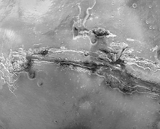 The planet Mars is one half the size of Earth with only one quarter of Earth's surface area. The gravitational force on Mars is one third of Earth's. By contrast the areological features are gigantic. Olympus Mons, the largest volcano known in the solar system, stands 26 km, or almost 3 times the height of Mt. Everest. Canyons, valleys, craters, out-wash flows, any surface feature is larger on average on Mars than Earth. The mystery science seeks to solve is why? How did these structures form? The forces and events must have been tumultuous. But where are the dynamics than shaped Mars's surface, now? Today Mars shows no sign of tectonic plate motion, no volcanism, and no running surface water to produce erosional features. The dynamic Earth continues to exhibit these forces. The planet Mars is one half the size of Earth with only one quarter of Earth's surface area. The gravitational force on Mars is one third of Earth's. By contrast the areological features are gigantic. Olympus Mons, the largest volcano known in the solar system, stands 26 km, or almost 3 times the height of Mt. Everest. Canyons, valleys, craters, out-wash flows, any surface feature is larger on average on Mars than Earth. The mystery science seeks to solve is why? How did these structures form? The forces and events must have been tumultuous. But where are the dynamics than shaped Mars's surface, now? Today Mars shows no sign of tectonic plate motion, no volcanism, and no running surface water to produce erosional features. The dynamic Earth continues to exhibit these forces.If we are to compare Earth and Mars, we must learn much more about the historical "geology" which took place on both planets . Our satellites and landed robotic probes, now and in the future, collect information which may lead to answering this exciting mystery. New understandings of Martian history are being written today, as a steady stream of information pours back to us. A new view of Mars is forming. Is this view of Mars we now see, a picture of Earth's past, two billion years ago, or is it Earth's future?
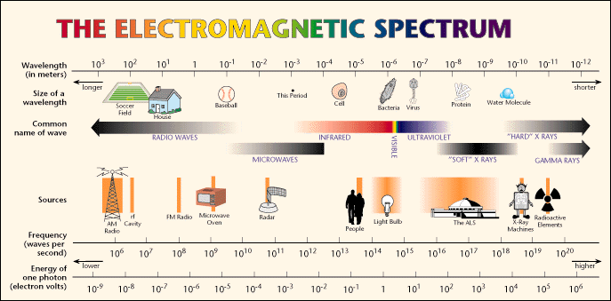
Launched in November 1996, the space craft traveled for 10 months to reach Mars followed by a year of positioning. In March 1999 its mission will officially begin. The Mars Orbiting Camera - MOC, will produce a photographic record and MOLA, the Mars Orbiter Laser Altimeter, will map the Martian topography. MGS will fly around Mars in a near circular orbit at an altitude range of 375 km to 445 km above the surface. The orbital period will be 117 minutes, repeating approximately every 7 Martian days. MOLA - Mars Orbiter Laser Altimeter An altimeter measures altitude, the height a plane or satellite is above a planet's surface. A laser altimeter uses focused light pulses to do the same. MOLA's solid state laser fires short pulses of infrared light 10 times per second at the surface of Mars and measures the time for the reflections to return. Upon return to the satellite, a telescope focuses the light scattered by the terrain and possibly clouds, onto a series of detectors. By knowing the speed of light, the satellite's position and its height above the planet, one can map the surface based on the return time of the pulse. The heights of mountains and the depths of valley's will be revealed to a precision of 40 centimeters. Laser altimeters have a small footprint on the planet's surface. MOLA's beam is only 130 meters wide. Each track along the planet's surface measures elevation continuously.
In 1976 two space craft were sent to map Mars and then land to take surface pictures and conduct tests. These were Viking I and II. Prior to these missions the Mariner 9 craft was sent to the planet on a mapping mission. Mariner images where used to select Viking landing sites. Viking images became the basis for determining the landing site of the Mars Pathfinder in 1997. They were made by way of radar altimetry. While there are many forms of radar altimeters, they differ from laser altimeters in two ways;
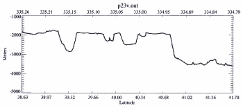
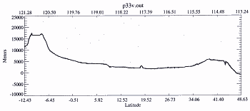
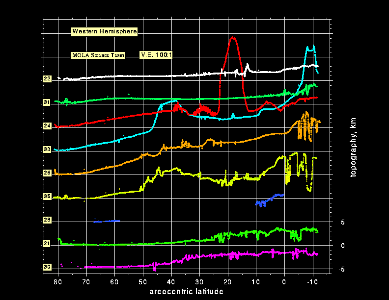 Vertical Exaggeration Vertical ExaggerationIn our investigation we will be working with topographic data returned from the MOLA instrument. Data sets are often compressed horizontally so they take less space and graph more easily. We will need to keep this in mind. The graph, (right - click for detail) serves as an example. Note the V.E. 100:1. This ratio means that the vertical is exaggerated 100 times for each unit on the horizontal. For example track 24 has a huge spike structure. This is actually the profile of Olympus Mons. This broad based shield volcano returns to its true shape when you add 100 units to the horizontal for each 1 on the vertical scale. Scale of Profiles Another item to remember when working with graphs is to watch the scale on the y-axis. As one decompresses the data, each zoom in, changes the scale.
Note on both profiles that latitude is represented on the bottom. While not labeled, the longitude is displayed at the top. Note the zero on the first profile's y-axis. This represents the "areoid." On Earth the "geoid" is the hypothetical mean elevation of Earth's surface, which coincides most of the time with mean sea level. For a planetary reference point on Mars, science calculates the areoid. To express it simply, it's an average of the highest and lowest elevations. Negative values on this axis is below the areoid It is a lowland, but does not mean below sea level. It does not correspond to "what the sea level was when Mars had an ocean." Basics of Mars Erosional and Tectonic Features Our point of reference for the study of Mars will be Earth features.
Return to the MOLA Index |
The Caves of Mars Project is funded by a NIAC Phase II Grant from the NASA Institute for Advanced Concepts.
Copyright © 2002-04 - Complex Systems Research; Inc.
Copyright © 2002-04 - Complex Systems Research; Inc.