
MOLA: Proceedure
Orientation:
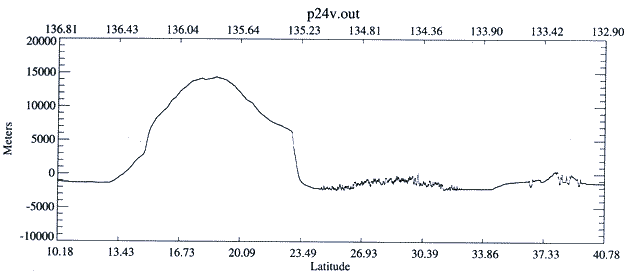
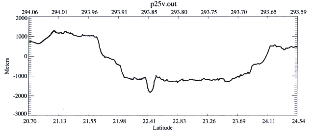
- Use hardcopies of the six "Selected Profiles" that can be printed from the links in the profile number section below.
- Study each profile to identify the following tectonic and erosional features.
- Neatly bracket each structure you find in pencil. Draw a line to the margin and label the structure.
Profile Number Aerological Features To Find:
The Latitude / Longitude Treasure Hunt:
Teacher Note:
Teachers should work through the lab, identify the 6 Viking Maps that are needed and print them on a laser printer. If you laminate them they can be used many times by students using water based transparency markers. Since the lightest shadow may represent a crater, photocopying multiple copies will diminish resolution. Students need to work from an original.
Tip - Keep This In Mind:
The MOLA flight path is not true north to south. It flys 1.5 degrees on the diagonal from NE to SW.
In this part you will use the six Selected Profiles of MOLA track data. Try to locate each on the Viking atlas images. You need to have a copy of each Viking Map and the "Treasure Hunt Summary" sheet.
- Book mark the following website of the Mars Viking Atlas.
- First time user- read through the introductory information.
- Within the blue box is an active gridded atlas of Mars. You may wish to cruse the planet, clicking and zooming in on any zone. This way you can learn to use the atlas and become familiar with surface features.
- When you are ready to begin the treasure hunt, follow the lat./longs. and click and zoom in on the atlas. Then study the profile and try to locate the features represented on the profile. You are trying to determine the flight path taken by the satellite. Note: The profile covers only a small segment of the Viking image. The ‘p' before each, stands for pass. You may ignore the 'v'.
- Answer the questions on the Treasure Hunt Summary as you work with each profile.
Profile Number Aerological Features To Find:
Ground Truthing:
- To ground truth you will now check your efforts at locating areological features on the Viking images, by using images with the flight paths overlayed.
- Book mark the Geodynamics website.
- Scroll down to the- "First Set of MOLA Pass Maps".
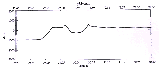
- We will walk through the first one together. Click on pass 35. Scroll down to the list of latitudes. Our profile segment lies between 29.78 and 30.30, so choose 20-32.
- The dashed black line is the MOLA flight path. Use the lat./long. to find the structures in the profile.
- Hold your Viking Map, where you drew the flight path, up to the screen and check your skill at reading profiles, areological features and lat./long.
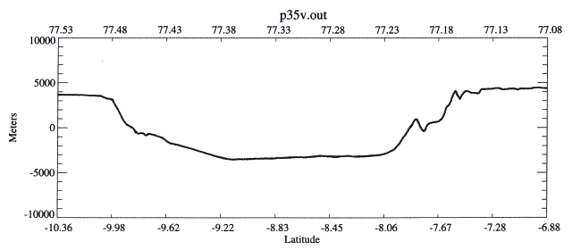
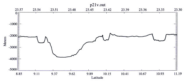
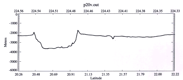
- Now repeat this process for the other five profiles.
Teacher Note:
Friendly competition between lab teams could be created. Use a metric rule to measure, on the screen, the distance the team is off from the plotted answer. Total all six profiles. Low "error total" wins.
Resources:
The following sites are good sources of general Mars information.
Collection of recent images:
Extension Activities:
- The Not So Grand Canyon
Action: Graph profiles of the Grand Canyon and Valles Marineris
Goal: To recognize the extreme size of features on Mars, when compared to the planet's size.
Grade Level: 9-12
Materials:
Procedure:
- Craters Have a Story To Tell - Can You Read It?
Teacher Note: This data is fresh from space and there is no established scale as yet. Remind the students of this and watch the y-axis. By next year a standard scale should be in place.
Action: Analyze four crater profiles.
Goal: To provide a basic first exploration of Martian craters.
Grade Level: 9-12
Materials: metric ruler, protractor, copies of four crater profiles and the Crater Activity Student Sheet
Background: "Complex craters" form when gravity causes the walls of larger craters to collapse downward and inward forming a central peak.
Vocabulary:
- central peak- a mountain found in the center of large craters, formed by a "rebound" of the rock at the impact site.
- crater- a usually circular depression in a surface caused by an impact
- ejecta- material through out of the crater
- ejecta blanket- ejecta tossed out at low speed, laying like a blanket around the crater
- floor-bottom interior of the crater, it is flat in the larger craters
- rampart (rim)- height of crater wall, measured from the outside; formed by the outwards and upwards compression of the crater walls, not ejecta
Links:
Astronomy Picture
Craters
Iturralde Structure
Procedure: (Complete the Crater Activity Student Sheet as you proceed.)
- Collect the following measurements.
Crater Depth
(meters) |
Left Wall Angle
(degrees) |
Right Wall Angle
(degrees) |
1
|
1
|
1
|
2
|
2
|
2
|
3
|
3
|
3
|
4
|
4
|
4
|
a. Use a metric ruler to measure the depth. Move to the y-axis scale and convert to meters.
b. Use the protractor to measure the left and right crater wall angles.
- Compare the crater walls for symmetry.
- Determine the steepness of the crater walls.
- Compare the profile to the top view image from the Viking Atlas.
- Calculating Slopes
Action: Students will use MOLA profiles and calculate slope.
Goal: To understand how slope can be calculated from Mars profiles and compare this to the more simple method they can use to measure Earth slopes.
Grade Level: 11-12 (Higher Math Functions Required)
Materials: calculator, metric ruler, slope profiles
Procedure:
- Provide students copies of the slope profiles.
- Steps Example
- Draw slope line with ruler from |-----------------| point to point.
- One inch = 0.8o of latitude.
- Determine the line length. 3.75 inches
- Calculation - solve for degrees of latitude3.75 in. X 0.8o = 3o
- Convert degrees into meters.
degrees X constant = meters3 X 59288 = 177,864 meters
- Determine the height.
Use a ruler to help you measure the height from the profile.height= 1200 meters
- Take the tangent
height1200 = 0.0067
length177,864
- Calculate the arctangent of above answer to get degrees of slope.Slope = 0.4o
Follow these steps to calculate the slopes.
- Summary
To put the meaning of slope into perspective, students could take measurements on a hill at the school campus or near by. Then do slope claculations. Have students write out their plan on how to calculate the slope of the hill. There are numerous methods. Guide them to one that is correct.
- Student Follow Up
Research the following slopes. Source
- average slope of interstate highways State Highway Engineer
- greatest practical slope on interstate highway"
- average rail bed slopeRailroad Engineer
- greatest possible railroad slope "
- desirable field slope for various crops
Local Soil Survey for corn, hay & soybeans National Resource Conservation Service
- Laser Ping-Pong Altimetry Lab
Action: Students simulate the functioning of an altimeter by timing the velocity of a ping pong ball.
Goal: To learn through a hands-on experience the basic concepts behind the use of a laser altimetry.
Grade Level: 9-12
Procedure: click here
- You Be The Planetologist
Action: Team brainstorms a hypothesis to the assigned question.
Goal: To give students opportunity to review Mars information and to polish team problem solving skills.
Grade Level: 9-12
Materials: wall chart paper, markers
Procedure:
- Each team seeks to produce their best proposed answer to the question;
Based on what you know of Earth's geology and what you have learned about Mars areology, what is your teams explaination for what forces or processes lead to the creation of such large surface structures on Mars?
- The time limits for such an activity is highly variable based on the level of detail you wish or their knowledge base.
- Teams could rough out their thoughts on scrap paper and report their polished thoughts in wall chart form on large paper.
- Later they should verbalize and defend their thoughts. As teachers we will accept any proposed reason that does not contradict taught and known facts.
Return to the MOLA Index
|